In late June 2024, scientists from Scripps Institution of Oceanography, Naval Postgraduate School, University of North Carolina, and University of the Virgin Islands performed preparatory fieldwork for the next “steep cliffs” ROXSI experiment for Winter 2024-25. The preparatory field work was conducted along the cliffs near Bordeaux Bay in St. Thomas from June 18-20. In order to mount pressure sensors … Read More
A Structure from Motion Perspective of the Small-Scale Array
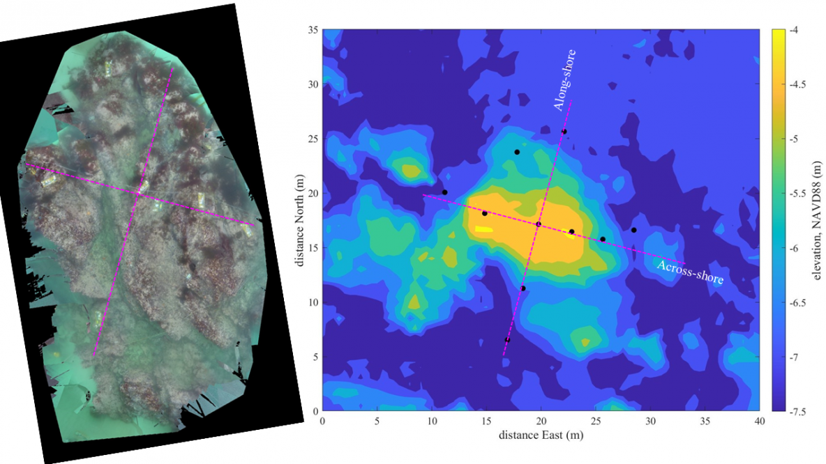
Left: Ortho mosaic of the instrumented rock at Asilomar, obtained by stitching GoPro photos. Right: multibeam bathymetry with instrument positions indicated by black dots. Magenta lines are across-shore and along-shore transects along which instruments were placed. On the last day deploying instruments in the small-scale array, visibility was amazing and we could even see the instruments from the surface. Loren … Read More
Monday Jun 27th: Start of Divejet Survey
The waves were minimal today, which made for a great day to bring out the divejet for the survey. A Signature 1000 ADCP was mounted on the divejet with the transducers facing down as drivers drove around the array on the surface of the water to cover areas that weren’t already covered by instruments. Drivers took 45-60 minute shifts on … Read More
Friday Jun 24th: Nearing the finish
Friday was another classic Monterey morning and the whole team would be offshore today finishing up deployments at the China Rock array and continuing work on the small-scale array. One of the previously deployed smart moorings at China Rock was having issues so the day began with the task of recovering that mooring and replacing it with a new smart … Read More
Tuesday Jun 21st: Tricky GPS Marking of Instrument Locations
No offshore work was done today. At low tide, GPS marking was done at China Rock. Unfortunately, this low tide was not as low as the low tide that coincided with the initial deployment of the nearshore instruments, which meant that most of the instruments were deeper underwater and harder to see. With no surface expression buoys marking the ADCPs, … Read More
- Page 1 of 2
- 1
- 2


